
What Is a Topographic Survey and Do You Need One?
Most people have heard of a boundary survey. Fewer people know what a topographic survey is, even though it plays a major role in construction and land development. If you are planning to build on a property, a topographic survey may be the first thing you actually need. Here is what it is, what it shows, and when it makes sense to get one.
What a Topographic Survey Actually Measures
A topographic survey maps the physical surface of a piece of land. Unlike a boundary survey, which focuses on legal property lines, a topographic survey focuses on what the land itself looks like.
It records:
- Elevation changes. How high or low different parts of the land sit, measured from a known reference point.
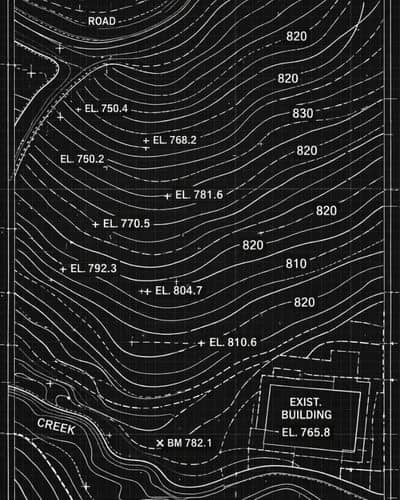
- Contour lines. Lines that connect points of equal elevation across the property. They show the shape and slope of the terrain.
- Natural features. Trees, streams, rock outcroppings, wetlands, and other natural elements on the site.
- Man-made features. Existing structures, driveways, walls, utility poles, and anything else already built on or near the land.
- Drainage patterns. Where water naturally flows across the site based on the slope and grade.
The finished product is a detailed map, sometimes called a topo map or contour map. Architects, engineers, and contractors use it to understand the land before any design work begins.
Why the Shape of Your Land Matters
It is easy to look at a piece of land and think it is flat. In reality, most lots have subtle changes in grade that are hard to see but have a big impact on construction.
Even a small slope affects where water drains after a rain. A grade that runs toward a house foundation instead of away from it can cause long-term water damage. A slope that looks gentle on paper might require significant grading, retaining walls, or drainage work to make a building site usable.
A topographic survey gives your design team the actual numbers. They use that data to plan where the building sits, how the driveway grades, where drainage flows, and what grading work the site needs before construction starts.
Skipping the topo survey and building from visual assumptions is a common and expensive mistake. Problems with drainage, foundation placement, and grading discovered after construction begins cost far more to fix than they would have cost to plan around in the first place.
Who Uses a Topographic Survey
Topographic surveys are used across a wide range of projects. The most common ones include:
New Home Construction
Before a house is designed, the architect and engineer need to know how the land sits. The foundation type, floor elevation, and drainage plan all depend on what the topo survey reveals. In hilly or rolling terrain, this step is especially important.
Land Development and Subdivision
When a developer plans to divide a larger parcel into multiple lots, a topographic survey of the full site helps determine where roads will go, how lots will be graded, and where drainage infrastructure is needed. This connects closely to the subdivision process covered in the article on how to go about subdividing a property.
Site Planning for Commercial Projects
Commercial buildings, parking lots, and access roads all require careful site grading. A topographic survey feeds directly into the civil engineering plans that govern how a commercial site gets developed.
Drainage and Flooding Analysis
Understanding how water moves across a property is critical in areas with heavy rainfall or near water bodies. A topo survey shows the natural drainage paths and helps engineers design systems that move water safely away from buildings and off the site.
Landscaping and Grading Projects
Even without a new building involved, a topographic survey helps landscapers and grading contractors understand what they are working with before they bring in equipment.
How a Topographic Survey Is Done
A licensed land surveyor collects the data using a combination of field instruments and, increasingly, aerial technology.
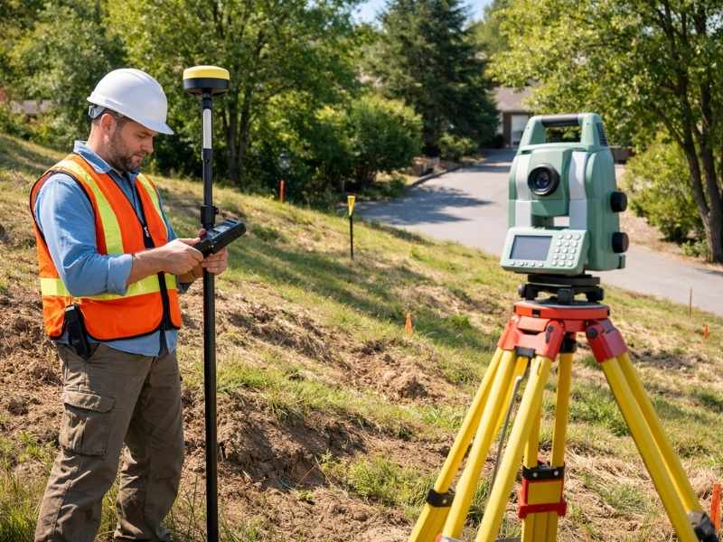
Traditional fieldwork uses a total station or GPS equipment to record elevation readings at many points across the site. The denser the grid of readings, the more detailed the final map. Surveyors also walk the site to record the location of features like trees, structures, and drainage channels.
On larger or more complex sites, drone-mounted sensors and LiDAR technology can collect thousands of elevation points in a fraction of the time it would take a ground crew. The data is then processed into a highly accurate digital model of the terrain.
The final deliverable is typically a CAD drawing or digital file showing contour lines, spot elevations, and feature locations. This file goes directly to the project’s architects and engineers.
How a Topographic Survey Differs From a Boundary Survey
These two surveys are often confused, but they serve different purposes.
A boundary survey answers the question: where does my property legally begin and end?
A topographic survey answers the question: what does the surface of my property actually look like?
One is about legal ownership. The other is about physical conditions. They are sometimes ordered together, especially for new construction projects where both the legal boundaries and the site conditions are needed before design work can start.
What a Topographic Survey Costs
Topographic survey costs vary based on the size of the property, the complexity of the terrain, and the level of detail required. Heavily wooded sites or properties with significant elevation changes take longer to survey than open, flat parcels.
As a general guide, residential topographic surveys typically range from $500 to $1,200. Larger or more complex sites can run higher. The cost is almost always a small fraction of what poor site planning would cost if drainage or grading problems surface during or after construction.