
How Do You Find Your Property Lines? Start Here
Not knowing exactly where your property lines are is more common than most people think. You might have a general idea based on where your lawn ends or where a fence sits. But those visual clues are often wrong. If you own property, knowing your actual property lines is not just useful. In some situations, it is essential.
Why Property Lines Are Not Always Obvious
Property lines are legal boundaries. They exist on paper, in recorded deeds, and on official plat maps. They do not always match what you can see on the ground.
Fences get built in the wrong place. Trees grow and shift over time. Old survey stakes rust, fall over, or get pulled out during landscaping. Neighbors agree on an informal boundary that turns out to be different from what the deed says.
None of those visible clues carry legal weight. The legal line is wherever a licensed surveyor determines it to be, based on recorded documents and measured fieldwork.
Start With Your Deed
Your deed is the first place to look. It contains a written legal description of your property. That description uses one of a few formats.
Metes and bounds is one of the oldest formats. It describes the property by starting at a specific point and moving in measured directions and distances around the perimeter. You might see language like “thence North 45 degrees East, 150 feet.” This format is common in older Alabama properties.
Lots and blocks are simpler. It references a lot number within a recorded subdivision plat. The description points to a map on file at the county level rather than describing the lines in full.
Government survey descriptions use a grid system of townships, ranges, and sections to identify a parcel. This is less common in residential settings but appears on larger rural parcels.
Reading your deed gives you the written description. It does not show you the lines on the ground. For that, you need to take the next step.
Check the County Plat Records
Your county probate office or tax assessor keeps recorded plat maps for subdivisions and surveyed parcels. In Tallapoosa County, where Alexander City is located, these records are available through the county offices and increasingly through online GIS mapping portals.
A plat map shows the layout of a subdivision or a surveyed parcel, including lot dimensions, boundary lines, easements, and rights-of-way. It gives you a visual picture of how your lot fits within the larger recorded plan.
Plat maps are useful starting points. They show the intended layout at the time of recording. But they do not always reflect what is currently on the ground, especially on older properties where conditions have changed over the years.
Use an Online GIS Map as a Starting Point
Many Alabama counties provide free online GIS mapping tools that show parcel boundaries overlaid on aerial photos. Tallapoosa County has parcel mapping data available through the county’s online portal.
These tools are helpful for getting a general sense of where your lot sits relative to neighboring parcels. They show approximate boundary lines drawn from recorded data.
The key word is approximate. Online GIS maps are not survey-accurate. The boundary lines shown are derived from recorded documents and are often plotted to within several feet of the true legal line. They are useful for orientation, not for making decisions about construction, fencing, or legal disputes.
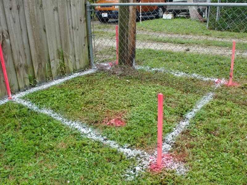
Look for Existing Survey Markers
If your property has been surveyed before, there may be physical markers on the ground. These are typically iron pins or rebar driven into the ground at the property corners, sometimes capped with a small metal disk stamped with the surveyor’s information.
To find them, you can use a metal detector along the likely corner locations based on your plat map. Corners are often near the intersection of your lot lines, at the front corners near the road, and at the back corners of the lot.
Finding an existing marker is useful, but it does not guarantee accuracy. Markers can be moved, disturbed by construction or landscaping, or placed incorrectly in an older survey. A licensed surveyor can verify whether the markers you find are valid and in the correct location.
When You Need a Surveyor
Online maps, plat records, and existing markers can give you a general idea of where your lines are. But there are situations where a general idea is not enough.
You need a licensed land surveyor when:
- You are planning to build a fence and want to be certain it goes on the right side of the line.
- You are adding a structure and need to confirm setback compliance for a permit.
- You have a dispute with a neighbor over where the boundary actually sits.
- You are buying or selling the property and need legally verified boundary information.
- You found markers but are not sure they are accurate or in the original position.
A boundary survey, covered in more detail in the article on what a boundary survey is, is the legal and measured way to confirm your property lines. It is the only method that holds up in a permit office, at a title company, or in a court of law.
What Property Line Markers Look Like
Knowing what to look for helps when you are searching for existing markers on your lot.
The most common markers are iron pins, which are steel rods or rebar typically half an inch in diameter and at least eighteen inches long. They are driven into the ground flush with the surface or just below it.
Some pins have a small aluminum or plastic cap attached to the top. The cap is usually stamped with the surveying firm’s name or the surveyor’s license number.
In older surveys or rural properties, you might also find concrete monuments, which are larger and heavier, or even rock or wood stakes in very old surveys. These older markers are less reliable and should be verified by a current survey before being used for any construction or legal purpose.
Frequently Asked Questions
Can I use Google Maps or satellite images to find my property lines?
No. Google Maps and satellite images do not show legal property boundaries. Any lines you see overlaid on mapping tools are approximations drawn from recorded data and can be off by several feet or more. They are useful for general orientation only.
What do I do if I cannot find any survey markers on my property?
Start by checking your deed and the county plat records to understand what survey was done and when. If the property has never been surveyed, or if the last survey was done many years ago, a new boundary survey is the reliable way to establish and mark your corners.
Can my neighbor and I just agree on where the line is?
You can reach a written agreement, but it needs to be handled carefully to be legally binding. In Alabama, boundary line agreements between neighboring property owners can be recorded, but they should be reviewed by a property attorney and ideally supported by a survey. A handshake agreement has no legal standing.
Are property lines the same as fence lines?
Not necessarily. A fence may have been built along the correct property line, or it may have been built in the wrong place entirely. A fence is a physical structure. A property line is a legal boundary. The two do not always match, which is one of the most common sources of neighbor disputes in residential areas.
What is a property line encroachment and how do I know if I have one?
An encroachment happens when a structure crosses over a property line onto a neighboring parcel. It could be a fence, a driveway, a shed, or even part of a building. A boundary survey will identify any encroachments and document them officially. For more on how encroachments are handled, the article on how to deal with property encroachment covers that topic in detail.